


Trail(07) - Croix de Millet - 17km - 717 m+

HG74250
User
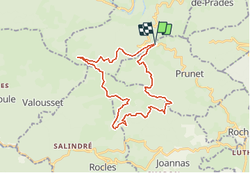

Length
16.6 km

Max alt
1201 m

Uphill gradient
717 m
Km-Effort
26 km

Min alt
651 m

Downhill gradient
720 m
Boucle
Yes
Creation date :
2021-05-13 17:40:29.171
Updated on :
2021-05-13 17:41:34.682
3h00
Difficulty : Difficult

FREE GPS app for hiking
 SityTrail
IGN / Geographical institutes
SityTrail Plus
The world is yours!
About
Trail Trail of 16.6 km to be discovered at Auvergne-Rhône-Alpes, Ardèche, Prunet. This trail is proposed by HG74250.
Positioning
Country:
France
Region :
Auvergne-Rhône-Alpes
Department/Province :
Ardèche
Municipality :
Prunet
Location:
Unknown
Start:(Dec)
Start:(UTM)
598610 ; 4940039 (31T) N.
Comments