


12 Ste Eulalie de Cernon orchidees

Nathy8913
User
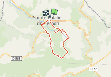

Length
6.7 km

Max alt
790 m

Uphill gradient
249 m
Km-Effort
10.1 km

Min alt
575 m

Downhill gradient
253 m
Boucle
Yes
Creation date :
2021-05-14 11:51:45.026
Updated on :
2021-05-16 11:33:47.393
4h03
Difficulty : Easy

FREE GPS app for hiking
 SityTrail
IGN / Geographical institutes
SityTrail Plus
The world is yours!
About
Trail Walking of 6.7 km to be discovered at Occitania, Aveyron, Sainte-Eulalie-de-Cernon. This trail is proposed by Nathy8913.
Positioning
Country:
France
Region :
Occitania
Department/Province :
Aveyron
Municipality :
Sainte-Eulalie-de-Cernon
Location:
Unknown
Start:(Dec)
Start:(UTM)
510942 ; 4869957 (31T) N.
Comments