


les planches en montagne p parcours

cocodu39
User
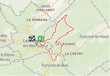

Length
16.3 km

Max alt
1115 m

Uphill gradient
499 m
Km-Effort
23 km

Min alt
723 m

Downhill gradient
500 m
Boucle
Yes
Creation date :
2021-05-13 07:45:37.264
Updated on :
2021-05-19 14:11:34.293
5h00
Difficulty : Very difficult

FREE GPS app for hiking
 SityTrail
IGN / Geographical institutes
SityTrail Plus
The world is yours!
About
Trail Walking of 16.3 km to be discovered at Bourgogne-Franche-Comté, Jura, Les Planches-en-Montagne. This trail is proposed by cocodu39.
Positioning
Country:
France
Region :
Bourgogne-Franche-Comté
Department/Province :
Jura
Municipality :
Les Planches-en-Montagne
Location:
Unknown
Start:(Dec)
Start:(UTM)
271192 ; 5170868 (32T) N.
Comments