


Chapelle saint Michel

Arnaud Stévenard
User

Length
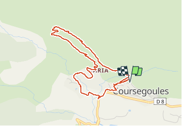
5.1 km

Max alt
1141 m

Uphill gradient
201 m
Km-Effort
7.8 km

Min alt
955 m

Downhill gradient
202 m
Boucle
Yes
Creation date :
2021-05-15 12:01:04.0
Updated on :
2021-05-15 14:55:05.735
1h49
Difficulty : Very easy

FREE GPS app for hiking
 SityTrail
IGN / Geographical institutes
SityTrail Plus
The world is yours!
About
Trail Walking of 5.1 km to be discovered at Provence-Alpes-Côte d'Azur, Maritime Alps, Coursegoules. This trail is proposed by Arnaud Stévenard.
Positioning
Country:
France
Region :
Provence-Alpes-Côte d'Azur
Department/Province :
Maritime Alps
Municipality :
Coursegoules
Location:
Unknown
Start:(Dec)
Start:(UTM)
342500 ; 4850967 (32T) N.
Comments