Trail Walking Lüdenscheid - w-duitsland-sauerland-wandeling-nabij-ludenscheid - Photo

w-duitsland-sauerland-wandeling-nabij-ludenscheid

© OpenStreetMap contributors
Length
Length
21 km
Max alt
Max alt
504 m
Uphill gradient
Uphill gradient
750 m
Km-Effort
Km-Effort  
31 km
Min alt
Min alt
237 m
Downhill gradient
Downhill gradient
748 m
Boucle
Boucle
Yes
Creation date :
2014-12-10 00:00:00.0
Updated on :
2014-12-10 00:00:00.0

(0 Reviews)

Walking
Walking
--
Difficulty : Unknown

Scan this QR Code to open this trail in the SityTrail application

FREE GPS app for hiking

Logo SityTrail SityTrail

IGN / Geographical institutes

Download SityTrail from the App Store Download SityTrail from Google Play

Logo SityTrail SityTrail World

The world is yours!

Download SityTrail from the App Store Download SityTrail from Google Play Download SityTrail on Huawei AppGallery

About

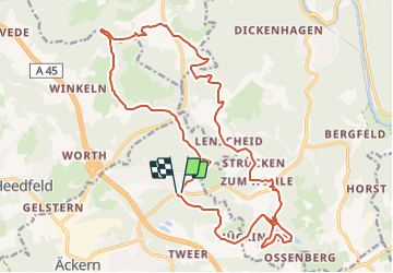
Trail Walking of 21 km to be discovered at North Rhine-Westphalia, Märkischer Kreis, Lüdenscheid. This trail is proposed by gpstracks.

Description

More information on GPStracks.nl : http://www.gpstracks.nl

Elevation profile

Points of interest

Point of interest Nachrodt-Wiblingwerde - Korenmolen, café - Photo
gpstracks
NACHRODT-WIBLINGWERDE 
Point of interest Nachrodt-Wiblingwerde - Oliemolen - Photo
gpstracks
NACHRODT-WIBLINGWERDE 
Point of interest Lüdenscheid - Parkeer - Photo
gpstracks
LÜDENSCHEID 
Point of interest Lüdenscheid - START - Photo
gpstracks
LÜDENSCHEID 

Positioning

Country:
Germany
Region :
North Rhine-Westphalia
Department/Province :
Märkischer Kreis
Municipality :
Lüdenscheid
Location:
Unknown
Start:(UTM)
404612 ; 5679057 (32U) N.

Trails nearby

Trail On foot Altena - [Quadrat] Selve-Weg - Photo
On foot
PRO

On foot

Easy
Altena, North Rhine-Westphalia, Märkischer Kreis, Germany
6 km | 9.6 km-effort
2h 11min
Yes
Trail On foot Altena - [A1] Am Schwarzenstein - Photo
On foot
PRO

On foot

Easy
Altena, North Rhine-Westphalia, Märkischer Kreis, Germany
3.8 km | 5.8 km-effort
1h 19min
Yes
Trail On foot Altena - [A3] Burgblicke - Photo
On foot
PRO

On foot

Easy
Altena, North Rhine-Westphalia, Märkischer Kreis, Germany
5.9 km | 9 km-effort
2h 2min
Yes
Trail On foot Altena - [A2] Um den Tiergarten - Photo
On foot
PRO

On foot

Easy
Altena, North Rhine-Westphalia, Märkischer Kreis, Germany
8.7 km | 12.8 km-effort
2h 54min
Yes
Trail On foot Schalksmühle - [A4] Winkeln - Heedfeld - Photo
On foot
PRO

On foot

Easy
Schalksmühle, North Rhine-Westphalia, Märkischer Kreis, Germany
6.8 km | 9.3 km-effort
2h 6min
Yes
Trail On foot Schalksmühle - Hülscheid Dreieck weiß - Photo
On foot
PRO

On foot

Easy
Schalksmühle, North Rhine-Westphalia, Märkischer Kreis, Germany
6.7 km | 8.4 km-effort
1h 55min
Yes


Close
My subscriptions