


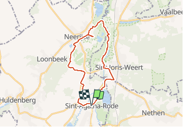
Sint Agatha Rode reserve

Cathy Minguet
User

Length
12.8 km

Max alt
86 m

Uphill gradient
134 m
Km-Effort
14.6 km

Min alt
23 m

Downhill gradient
134 m
Boucle
Yes
Creation date :
2021-05-16 09:33:52.0
Updated on :
2021-05-16 12:29:03.101
2h55
Difficulty : Difficult

FREE GPS app for hiking
 SityTrail
IGN / Geographical institutes
SityTrail Plus
The world is yours!
About
Trail Walking of 12.8 km to be discovered at Flanders, Flemish Brabant, Huldenberg. This trail is proposed by Cathy Minguet.
Positioning
Country:
Belgium
Region :
Flanders
Department/Province :
Flemish Brabant
Municipality :
Huldenberg
Location:
Sint-Agatha-Rode
Start:(Dec)
Start:(UTM)
615164 ; 5627392 (31U) N.
Comments