


2021-05-17_13h19m01_rGEWvlU6T4g-2

daniellebou
User
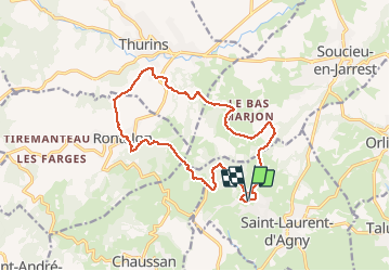

Length
15.3 km

Max alt
541 m

Uphill gradient
409 m
Km-Effort
21 km

Min alt
351 m

Downhill gradient
411 m
Boucle
Yes
Creation date :
2021-05-17 11:19:02.227
Updated on :
2021-05-21 17:02:32.307
4h42
Difficulty : Very difficult

FREE GPS app for hiking
 SityTrail
IGN / Geographical institutes
SityTrail Plus
The world is yours!
About
Trail Walking of 15.3 km to be discovered at Auvergne-Rhône-Alpes, Rhône, Saint-Laurent-d'Agny. This trail is proposed by daniellebou.
Description
importé de Visorando
Positioning
Country:
France
Region :
Auvergne-Rhône-Alpes
Department/Province :
Rhône
Municipality :
Saint-Laurent-d'Agny
Location:
Unknown
Start:(Dec)
Start:(UTM)
630362 ; 5056152 (31T) N.
Comments