


J2bis - depuis Mt Lozere

aeldin
User
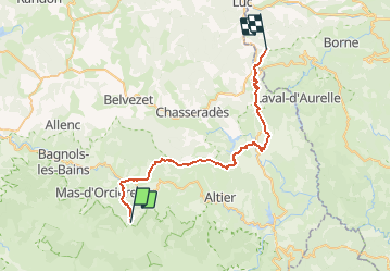

Length
37 km

Max alt
1418 m

Uphill gradient
984 m
Km-Effort
51 km

Min alt
843 m

Downhill gradient
1185 m
Boucle
No
Creation date :
2021-05-17 19:37:49.892
Updated on :
2021-05-17 19:42:36.733
--
Difficulty : Very easy

FREE GPS app for hiking
 SityTrail
IGN / Geographical institutes
SityTrail Plus
The world is yours!
About
Trail Equestrian of 37 km to be discovered at Occitania, Lozère, Cubières. This trail is proposed by aeldin.
Positioning
Country:
France
Region :
Occitania
Department/Province :
Lozère
Municipality :
Cubières
Location:
Unknown
Start:(Dec)
Start:(UTM)
559554 ; 4922422 (31T) N.
Comments