


Traversée massif vosgien (TMV)

lbguigui
User
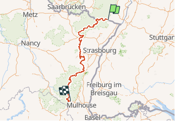

Length
393 km

Max alt
1251 m

Uphill gradient
12764 m
Km-Effort
563 km

Min alt
158 m

Downhill gradient
12585 m
Boucle
No
Creation date :
2021-05-18 05:24:53.912
Updated on :
2021-05-18 05:25:26.635
39h01
Difficulty : Very difficult

FREE GPS app for hiking
 SityTrail
IGN / Geographical institutes
SityTrail Plus
The world is yours!
About
Trail Mountain bike of 393 km to be discovered at Grand Est, Bas-Rhin, Wissembourg. This trail is proposed by lbguigui.
Description
Tracé officiel de la TMV
Positioning
Country:
France
Region :
Grand Est
Department/Province :
Bas-Rhin
Municipality :
Wissembourg
Location:
Unknown
Start:(Dec)
Start:(UTM)
422607 ; 5432257 (32U) N.
Comments