


Belvédère du diable

ezola
User
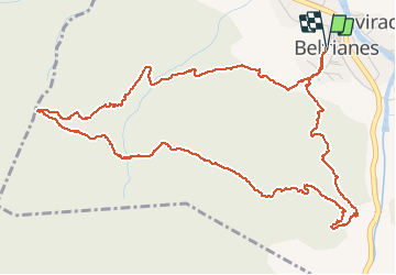

Length
7.4 km

Max alt
650 m

Uphill gradient
331 m
Km-Effort
11.8 km

Min alt
341 m

Downhill gradient
332 m
Boucle
Yes
Creation date :
2021-05-18 06:43:12.0
Updated on :
2021-05-18 09:28:56.712
2h15
Difficulty : Medium

FREE GPS app for hiking
 SityTrail
IGN / Geographical institutes
SityTrail Plus
The world is yours!
About
Trail Walking of 7.4 km to be discovered at Occitania, Aude, Belvianes-et-Cavirac. This trail is proposed by ezola.
Description
Chemin bleu sauf après le belvédère du diable possibilité de faire une variante un tronçon d’une demi-heure classifier plutôt noir
Photos


Positioning
Country:
France
Region :
Occitania
Department/Province :
Aude
Municipality :
Belvianes-et-Cavirac
Location:
Unknown
Start:(Dec)
Start:(UTM)
434585 ; 4744733 (31T) N.
Comments