Trail Walking Deux-Grosnes - Séjour RCY : Les crêtes du Haut Beaujolais journée 3 - Photo

Séjour RCY : Les crêtes du Haut Beaujolais journée 3

 chessyca
chessyca

User

© OpenStreetMap contributors
Length
Length
22 km
Max alt
Max alt
1007 m
Uphill gradient
Uphill gradient
768 m
Km-Effort
Km-Effort  
32 km
Min alt
Min alt
527 m
Downhill gradient
Downhill gradient
730 m
Boucle
Boucle
No
Creation date :
2021-05-19 05:56:46.055
Updated on :
2021-05-23 10:39:14.726

(0 Reviews)

Walking
Walking
5h42
Difficulty : Very difficult

Scan this QR Code to open this trail in the SityTrail application

FREE GPS app for hiking

Logo SityTrail SityTrail

IGN / Geographical institutes

Download SityTrail from the App Store Download SityTrail from Google Play

Logo SityTrail SityTrail World

The world is yours!

Download SityTrail from the App Store Download SityTrail from Google Play Download SityTrail on Huawei AppGallery

About

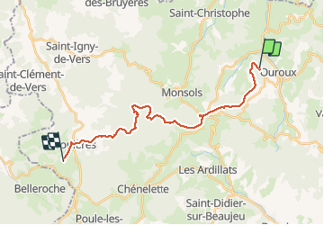
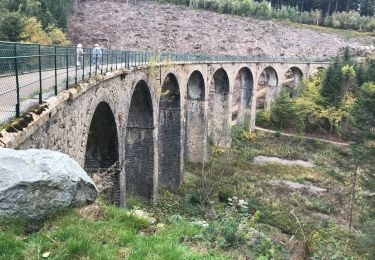
Trail Walking of 22 km to be discovered at Auvergne-Rhône-Alpes, Rhône, Deux-Grosnes. This trail is proposed by chessyca.

Description

3ème étape d'un trek de 6 jours.
Départ du Château de Grosbois pour aller sur la commune d'Ouroux.
Matinée très agréable mais après midi pluvieuse qui nous a fait modifier quelque peu le tracé initial.

Elevation profile

Photos

Positioning

Country:
France
Region :
Auvergne-Rhône-Alpes
Department/Province :
Rhône
Municipality :
Deux-Grosnes
Location:
Ouroux
Start:(UTM)
621867 ; 5121090 (31T) N.

Trails nearby

Trail Walking Deux-Grosnes - Circuit de Saint-Jacques des Arrêts - Photo
Walking
tracegps

Walking

Medium
(1)
Deux-Grosnes, Auvergne-Rhône-Alpes, Rhône, France
11.9 km | 17.3 km-effort
3h 0min
Yes
Trail Walking Deux-Grosnes - Ouroux - Photo
Walking
Galoche

Walking

Difficult
(1)
Deux-Grosnes, Auvergne-Rhône-Alpes, Rhône, France
19.1 km | 0 m-effort
5h 57min
Yes
Trail Walking Deux-Grosnes - Circuit n°1 du Mont Saint-Rigaud - Monsols - Photo
Walking
tracegps

Walking

Easy
(1)
Deux-Grosnes, Auvergne-Rhône-Alpes, Rhône, France
5.3 km | 7.2 km-effort
1h 19min
Yes
Trail Walking Vauxrenard - vauxrenard - Photo
Walking
Zeugma13

Walking

Difficult
(1)
Vauxrenard, Auvergne-Rhône-Alpes, Rhône, France
21 km | 31 km-effort
5h 7min
Yes
Trail On foot Deux-Grosnes - Circuit des Sapins - Photo
On foot
PRO

On foot

Difficult
Deux-Grosnes, Auvergne-Rhône-Alpes, Rhône, France
22 km | 33 km-effort
7h 34min
Yes
Trail On foot Deux-Grosnes - Circuit du Bois du Thym - Photo
On foot
PRO

On foot

Easy
Deux-Grosnes, Auvergne-Rhône-Alpes, Rhône, France
6.8 km | 10.6 km-effort
2h 24min
Yes
Trail On foot Deux-Grosnes - Circuit du Mont Saint-Rigaud 15 km - Photo
On foot
PRO

On foot

Easy
Deux-Grosnes, Auvergne-Rhône-Alpes, Rhône, France
8.6 km | 13.7 km-effort
3h 6min
No
Trail Walking Chiroubles - Fût d’Avenas  (13 km - D. 455 m) - Photo
Walking
Thomasdanielle

Walking

Medium
(1)
Chiroubles, Auvergne-Rhône-Alpes, Rhône, France
13 km | 19.1 km-effort
4h 21min
Yes
Trail Walking Les Ardillats - Col de crie au Viaduc (7,4 km - D. 173 m) - Photo
Walking
Thomasdanielle

Walking

Easy
Les Ardillats, Auvergne-Rhône-Alpes, Rhône, France
7.3 km | 9.5 km-effort
3h 15min
Yes


Close
My subscriptions