


cheverny. un

gerardh
User
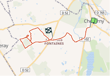

Length
7.4 km

Max alt
105 m

Uphill gradient
50 m
Km-Effort
8.1 km

Min alt
85 m

Downhill gradient
46 m
Boucle
No
Creation date :
2021-05-20 12:07:57.641
Updated on :
2021-05-20 13:55:06.656
1h46
Difficulty : Medium

FREE GPS app for hiking
 SityTrail
IGN / Geographical institutes
SityTrail Plus
The world is yours!
About
Trail Walking of 7.4 km to be discovered at Centre-Loire Valley, Loir-et-Cher, Cheverny. This trail is proposed by gerardh.
Positioning
Country:
France
Region :
Centre-Loire Valley
Department/Province :
Loir-et-Cher
Municipality :
Cheverny
Location:
Unknown
Start:(Dec)
Start:(UTM)
383910 ; 5261558 (31T) N.
Comments