


Daronne

nordan
User
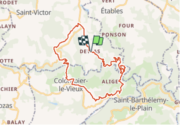

Length
19.5 km

Max alt
497 m

Uphill gradient
609 m
Km-Effort
28 km

Min alt
243 m

Downhill gradient
608 m
Boucle
Yes
Creation date :
2021-05-20 07:52:04.426
Updated on :
2021-05-20 14:23:53.829
6h30
Difficulty : Very easy

FREE GPS app for hiking
 SityTrail
IGN / Geographical institutes
SityTrail Plus
The world is yours!
About
Trail Walking of 19.5 km to be discovered at Auvergne-Rhône-Alpes, Ardèche, Saint-Victor. This trail is proposed by nordan.
Positioning
Country:
France
Region :
Auvergne-Rhône-Alpes
Department/Province :
Ardèche
Municipality :
Saint-Victor
Location:
Unknown
Start:(Dec)
Start:(UTM)
634710 ; 4993439 (31T) N.
Comments