


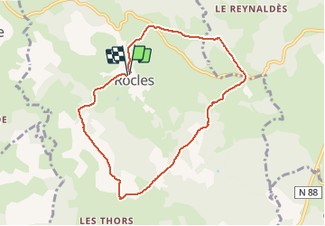
Rocles

FLORENSAC
User

Length
8.3 km

Max alt
1160 m

Uphill gradient
210 m
Km-Effort
11.1 km

Min alt
1003 m

Downhill gradient
206 m
Boucle
Yes
Creation date :
2021-05-20 12:18:29.861
Updated on :
2021-05-20 18:08:42.292
2h42
Difficulty : Medium

FREE GPS app for hiking
 SityTrail
IGN / Geographical institutes
SityTrail Plus
The world is yours!
About
Trail Walking of 8.3 km to be discovered at Occitania, Lozère, Rocles. This trail is proposed by FLORENSAC.
Description
petite rando
Au depart de Rocles
Se garer devant l eglise
Passer devant la fontaine
Et suivre le balisage jaune
Quelques montees 3,4
Photos


Positioning
Country:
France
Region :
Occitania
Department/Province :
Lozère
Municipality :
Rocles
Location:
Unknown
Start:(Dec)
Start:(UTM)
561973 ; 4951489 (31T) N.
Comments