


roc la tour. blossette.2.2021.05.20

trusgnachjf
User
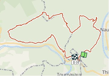

Length
14.3 km

Max alt
423 m

Uphill gradient
433 m
Km-Effort
20 km

Min alt
169 m

Downhill gradient
439 m
Boucle
Yes
Creation date :
2021-05-20 11:51:40.706
Updated on :
2021-05-20 15:46:12.449
3h53
Difficulty : Very difficult

FREE GPS app for hiking
 SityTrail
IGN / Geographical institutes
SityTrail Plus
The world is yours!
About
Trail Walking of 14.3 km to be discovered at Grand Est, Ardennes, Tournavaux. This trail is proposed by trusgnachjf.
Positioning
Country:
France
Region :
Grand Est
Department/Province :
Ardennes
Municipality :
Tournavaux
Location:
Unknown
Start:(Dec)
Start:(UTM)
628734 ; 5526550 (31U) N.
Comments