


04 Stevenson 2021

cmike39
User
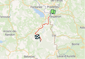

Length
21 km

Max alt
1273 m

Uphill gradient
652 m
Km-Effort
28 km

Min alt
909 m

Downhill gradient
293 m
Boucle
No
Creation date :
2021-05-20 06:30:50.095
Updated on :
2021-05-20 18:49:29.967
6h58
Difficulty : Very difficult

FREE GPS app for hiking
 SityTrail
IGN / Geographical institutes
SityTrail Plus
The world is yours!
About
Trail Walking of 21 km to be discovered at Occitania, Lozère, Langogne. This trail is proposed by cmike39.
Positioning
Country:
France
Region :
Occitania
Department/Province :
Lozère
Municipality :
Langogne
Location:
Unknown
Start:(Dec)
Start:(UTM)
568498 ; 4952918 (31T) N.
Comments