


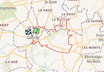
gavray

lionelnottat
User

Length
15.5 km

Max alt
169 m

Uphill gradient
319 m
Km-Effort
19.8 km

Min alt
29 m

Downhill gradient
318 m
Boucle
Yes
Creation date :
2021-05-21 07:52:24.368
Updated on :
2021-05-21 13:01:19.527
3h39
Difficulty : Medium

FREE GPS app for hiking
 SityTrail
IGN / Geographical institutes
SityTrail Plus
The world is yours!
About
Trail Walking of 15.5 km to be discovered at Normandy, Manche, Gavray-sur-Sienne. This trail is proposed by lionelnottat.
Description
belle rando empruntant des chemins abrités, variée, peu de routes. a faire même par temps venteux.
Positioning
Country:
France
Region :
Normandy
Department/Province :
Manche
Municipality :
Gavray-sur-Sienne
Location:
Gavray
Start:(Dec)
Start:(UTM)
620866 ; 5418801 (30U) N.
Comments