


Boucle d'ANNOT de 9.5km et 575m déniv

eaea7charles
User
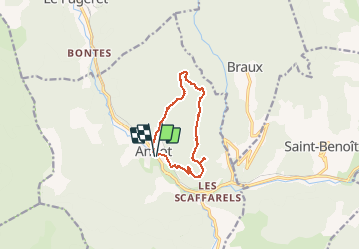

Length
9.7 km

Max alt
1191 m

Uphill gradient
575 m
Km-Effort
17.3 km

Min alt
689 m

Downhill gradient
575 m
Boucle
Yes
Creation date :
2021-05-21 13:52:57.513
Updated on :
2021-05-21 13:59:04.847
5h00
Difficulty : Difficult

FREE GPS app for hiking
 SityTrail
IGN / Geographical institutes
SityTrail Plus
The world is yours!
About
Trail On foot of 9.7 km to be discovered at Provence-Alpes-Côte d'Azur, Alpes-de-Haute-Provence, Annot. This trail is proposed by eaea7charles.
Description
au départ de la place du germe, en direction de la gare
Positioning
Country:
France
Region :
Provence-Alpes-Côte d'Azur
Department/Province :
Alpes-de-Haute-Provence
Municipality :
Annot
Location:
Unknown
Start:(Dec)
Start:(UTM)
312963 ; 4870621 (32T) N.
Comments