


05 Stevenson

cmike39
User
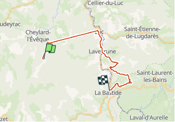

Length
23 km

Max alt
1271 m

Uphill gradient
639 m
Km-Effort
32 km

Min alt
969 m

Downhill gradient
891 m
Boucle
No
Creation date :
2021-05-21 06:17:44.707
Updated on :
2021-05-21 14:30:46.059
5h59
Difficulty : Very difficult

FREE GPS app for hiking
 SityTrail
IGN / Geographical institutes
SityTrail Plus
The world is yours!
About
Trail Walking of 23 km to be discovered at Occitania, Lozère, Cheylard-l'Évêque. This trail is proposed by cmike39.
Positioning
Country:
France
Region :
Occitania
Department/Province :
Lozère
Municipality :
Cheylard-l'Évêque
Location:
Unknown
Start:(Dec)
Start:(UTM)
564428 ; 4941449 (31T) N.
Comments