


LISPACH

surceneux
User
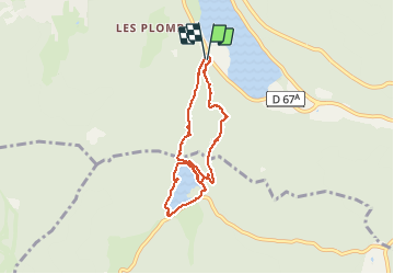

Length
7 km

Max alt
1012 m

Uphill gradient
317 m
Km-Effort
11.1 km

Min alt
748 m

Downhill gradient
299 m
Boucle
Yes
Creation date :
2021-05-21 13:05:35.89
Updated on :
2021-05-21 16:47:27.945
2h10
Difficulty : Medium

FREE GPS app for hiking
 SityTrail
IGN / Geographical institutes
SityTrail Plus
The world is yours!
About
Trail Walking of 7 km to be discovered at Grand Est, Vosges, Xonrupt-Longemer. This trail is proposed by surceneux.
Description
CAMPING LES JONQUILLES LONGEMER TRIANGLE ROUGE ROCHE DES VIEUX CHEVAUX FACHEPREMONT ANC. MINE CUIVRE LISPACH TOUR RETOUR COLLET DE LA MINE CROIX VERTE LONGEMER
Positioning
Country:
France
Region :
Grand Est
Department/Province :
Vosges
Municipality :
Xonrupt-Longemer
Location:
Unknown
Start:(Dec)
Start:(UTM)
347101 ; 5325837 (32U) N.
Comments