Trail Walking Bouquet - Le Puech boucle au nord du Mt Bouquet - Photo

Le Puech boucle au nord du Mt Bouquet

 jll7513
jll7513

User

© OpenStreetMap contributors
Length
Length
10.9 km
Max alt
Max alt
530 m
Uphill gradient
Uphill gradient
325 m
Km-Effort
Km-Effort  
15.2 km
Min alt
Min alt
256 m
Downhill gradient
Downhill gradient
326 m
Boucle
Boucle
Yes
Creation date :
2021-05-21 20:52:09.484
Updated on :
2021-05-23 08:20:52.194

(0 Reviews)

Walking
Walking
3h28
Difficulty : Medium
Nordic walking
Nordic walking
2h10
Difficulty : Easy

Scan this QR Code to open this trail in the SityTrail application

FREE GPS app for hiking

Logo SityTrail SityTrail

IGN / Geographical institutes

Download SityTrail from the App Store Download SityTrail from Google Play

Logo SityTrail SityTrail World

The world is yours!

Download SityTrail from the App Store Download SityTrail from Google Play Download SityTrail on Huawei AppGallery

About

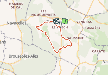
Trail Walking of 10.9 km to be discovered at Occitania, Gard, Bouquet. This trail is proposed by jll7513.

Description

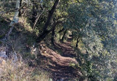
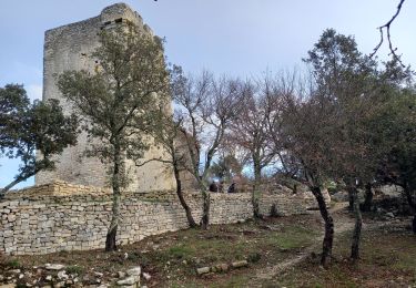
On démarre du hameau du Puech, depuis le petit parking situé derrière la mairie et l'église. Puis direction le nord vers le village de Bouquet. C'est une randonnée qui est très roulante avec des pistes larges en général. Idéal pour la marche nordique. Une petite portion de route depuis le col du bourricot. Mais dès que l'on a passé les deux épingles on reprend de nouveau un chemin. On retrouvera un peu de route avant d'arriver au hameau du Puech. Randonnée facile avec de très beaux points de vue. Affaire de bonne heure ou hors saison chaude, car très peu de portions ombragées.

Elevation profile

Photos

Positioning

Country:
France
Region :
Occitania
Department/Province :
Gard
Municipality :
Bouquet
Location:
Unknown
Start:(UTM)
603161 ; 4890345 (31T) N.

Trails nearby

Trail Walking Navacelles - Les Aiguiéres au départ de Call - Photo
Walking
GUIDE
Roger Philippe Wallez

Walking

Difficult
(1)
Navacelles, Occitania, Gard, France
10.4 km | 14.9 km-effort
4h 39min
Yes
Trail Walking Allègre-les-Fumades - château d allègre aiguieres - Photo
Walking
Vero7684

Walking

Medium
(1)
Allègre-les-Fumades, Occitania, Gard, France
16.9 km | 25 km-effort
6h 10min
Yes
Trail Walking Navacelles - Aiguieres par Cal - Photo
Walking
asclier0

Walking

Medium
(2)
Navacelles, Occitania, Gard, France
8.9 km | 12.6 km-effort
2h 20min
Yes
Trail Walking Brouzet-lès-Alès - Mont Bouquet  - Photo
Walking
GUIDE
nadinebondoux

Walking

Medium
Brouzet-lès-Alès, Occitania, Gard, France
14.5 km | 21 km-effort
3h 41min
Yes
Trail Walking Navacelles - Château d'Allegre / Aiguières  - Photo
Walking
GUIDE
nadinebondoux

Walking

Difficult
Navacelles, Occitania, Gard, France
20 km | 29 km-effort
7h 18min
Yes
Trail Walking Bouquet - Mont Bouquet au départ de Bouquet  - Photo
Walking
GUIDE
nadinebondoux

Walking

Difficult
Bouquet, Occitania, Gard, France
17 km | 26 km-effort
5h 11min
Yes
Trail Walking Allègre-les-Fumades - Argensol, chapelle St Saturnin, Château d'Alègre - Photo
Walking
asclier0

Walking

Difficult
Allègre-les-Fumades, Occitania, Gard, France
8.7 km | 12.1 km-effort
2h 44min
Yes
Trail Walking Allègre-les-Fumades - Chateau d'Allegre par les crêtes et défilé d'Argensol  - Photo
Walking
GUIDE
nadinebondoux

Walking

Medium
Allègre-les-Fumades, Occitania, Gard, France
9.5 km | 13 km-effort
3h 42min
Yes
Trail Walking Fons-sur-Lussan - Serre de Fons - Photo
Walking
xmayeur

Walking

Medium
Fons-sur-Lussan, Occitania, Gard, France
4.7 km | 6.7 km-effort
1h 39min
No


Close
My subscriptions