


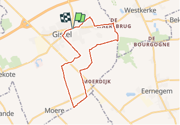
69.155 Gistel - Boergonje-vaardeken

ADL339
User

Length
13.5 km

Max alt
11 m

Uphill gradient
43 m
Km-Effort
14.1 km

Min alt
-3 m

Downhill gradient
43 m
Boucle
Yes
Creation date :
2021-05-22 10:54:56.0
Updated on :
2021-05-22 10:53:50.071
3h10
Difficulty : Easy

FREE GPS app for hiking
 SityTrail
IGN / Geographical institutes
SityTrail Plus
The world is yours!
About
Trail Walking of 13.5 km to be discovered at Flanders, West Flanders, Gistel. This trail is proposed by ADL339.
Positioning
Country:
Belgium
Region :
Flanders
Department/Province :
West Flanders
Municipality :
Gistel
Location:
Gistel
Start:(Dec)
Start:(UTM)
497855 ; 5667244 (31U) N.
Comments