


Mt St Michel

Lychee
User
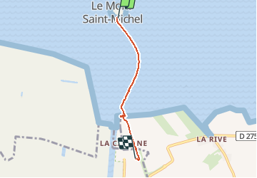

Length
3.1 km

Max alt
15 m

Uphill gradient
13 m
Km-Effort
3.3 km

Min alt
4 m

Downhill gradient
13 m
Boucle
No
Creation date :
2021-05-22 10:15:55.387
Updated on :
2021-05-22 10:59:52.866
40m
Difficulty : Easy

FREE GPS app for hiking
 SityTrail
IGN / Geographical institutes
SityTrail Plus
The world is yours!
About
Trail Walking of 3.1 km to be discovered at Normandy, Manche, Pontorson. This trail is proposed by Lychee.
Positioning
Country:
France
Region :
Normandy
Department/Province :
Manche
Municipality :
Pontorson
Location:
Pontorson
Start:(Dec)
Start:(UTM)
609674 ; 5387944 (30U) N.
Comments