


st peray lamastre 4x4

ikusen26@gmail.com
User
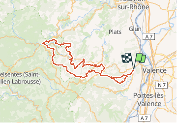

Length
78 km

Max alt
905 m

Uphill gradient
2253 m
Km-Effort
108 km

Min alt
143 m

Downhill gradient
2254 m
Boucle
Yes
Creation date :
2021-05-22 08:02:34.353
Updated on :
2021-05-23 20:14:39.704
--
Difficulty : Very easy

FREE GPS app for hiking
 SityTrail
IGN / Geographical institutes
SityTrail Plus
The world is yours!
About
Trail 4x4 of 78 km to be discovered at Auvergne-Rhône-Alpes, Ardèche, Saint-Péray. This trail is proposed by ikusen26@gmail.com.
Positioning
Country:
France
Region :
Auvergne-Rhône-Alpes
Department/Province :
Ardèche
Municipality :
Saint-Péray
Location:
Unknown
Start:(Dec)
Start:(UTM)
644692 ; 4977366 (31T) N.
Comments