


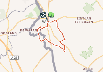
69.178 Watou - Omer de Schreve

ADL339
User

Length
9.3 km

Max alt
30 m

Uphill gradient
36 m
Km-Effort
9.8 km

Min alt
11 m

Downhill gradient
37 m
Boucle
Yes
Creation date :
2021-05-23 12:33:04.0
Updated on :
2021-05-23 12:31:29.442
2h13
Difficulty : Very easy

FREE GPS app for hiking
 SityTrail
IGN / Geographical institutes
SityTrail Plus
The world is yours!
About
Trail Walking of 9.3 km to be discovered at Flanders, West Flanders, Poperinge. This trail is proposed by ADL339.
Positioning
Country:
Belgium
Region :
Flanders
Department/Province :
West Flanders
Municipality :
Poperinge
Location:
Watou
Start:(Dec)
Start:(UTM)
473264 ; 5634201 (31U) N.
Comments