


Autour de Carnac

adubarry
User
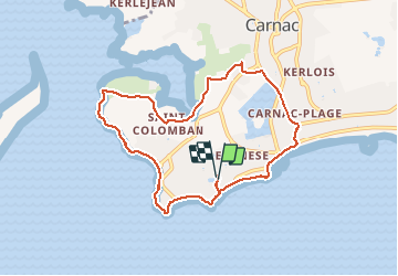

Length
8.2 km

Max alt
12 m

Uphill gradient
52 m
Km-Effort
8.9 km

Min alt
0 m

Downhill gradient
53 m
Boucle
Yes
Creation date :
2021-05-23 12:11:40.97
Updated on :
2021-05-23 14:49:35.802
2h23
Difficulty : Easy

FREE GPS app for hiking
 SityTrail
IGN / Geographical institutes
SityTrail Plus
The world is yours!
About
Trail Walking of 8.2 km to be discovered at Brittany, Morbihan, Carnac. This trail is proposed by adubarry.
Description
Ady Pt Clem Diane
Positioning
Country:
France
Region :
Brittany
Department/Province :
Morbihan
Municipality :
Carnac
Location:
Unknown
Start:(Dec)
Start:(UTM)
493399 ; 5268221 (30T) N.
Comments