


2021-05-24_10h36m30_boucle_1_pnr_connexion_senlis

gilbertdu60
User
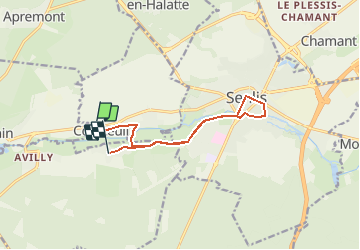

Length
10.3 km

Max alt
81 m

Uphill gradient
91 m
Km-Effort
11.5 km

Min alt
44 m

Downhill gradient
87 m
Boucle
No
Creation date :
2021-05-24 08:36:30.441
Updated on :
2021-05-24 08:36:30.781

FREE GPS app for hiking
 SityTrail
IGN / Geographical institutes
SityTrail Plus
The world is yours!
About
Trail of 10.3 km to be discovered at Hauts-de-France, Oise, Courteuil. This trail is proposed by gilbertdu60.
Positioning
Country:
France
Region :
Hauts-de-France
Department/Province :
Oise
Municipality :
Courteuil
Location:
Unknown
Start:(Dec)
Start:(UTM)
465929 ; 5449591 (31U) N.
Comments