


2021-05-24_10h37m58_balade 24 Avril 18

gilbertdu60
User
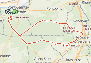

Length
20 km

Max alt
202 m

Uphill gradient
277 m
Km-Effort
24 km

Min alt
99 m

Downhill gradient
277 m
Boucle
Yes
Creation date :
2021-05-24 08:37:59.035
Updated on :
2021-05-24 08:38:00.527

FREE GPS app for hiking
 SityTrail
IGN / Geographical institutes
SityTrail Plus
The world is yours!
About
Trail of 20 km to be discovered at Hauts-de-France, Oise, Pont-Sainte-Maxence. This trail is proposed by gilbertdu60.
Positioning
Country:
France
Region :
Hauts-de-France
Department/Province :
Oise
Municipality :
Pont-Sainte-Maxence
Location:
Unknown
Start:(Dec)
Start:(UTM)
470633 ; 5460224 (31U) N.
Comments