


2021-05-24_10h50m27_boucle_3_pnr_ermenonville_connexion_senlis

gilbertdu60
User
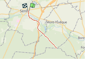

Length
11.3 km

Max alt
91 m

Uphill gradient
107 m
Km-Effort
12.7 km

Min alt
50 m

Downhill gradient
106 m
Boucle
Yes
Creation date :
2021-05-24 08:50:27.342
Updated on :
2021-05-24 08:50:27.954

FREE GPS app for hiking
 SityTrail
IGN / Geographical institutes
SityTrail Plus
The world is yours!
About
Trail of 11.3 km to be discovered at Hauts-de-France, Oise, Senlis. This trail is proposed by gilbertdu60.
Positioning
Country:
France
Region :
Hauts-de-France
Department/Province :
Oise
Municipality :
Senlis
Location:
Unknown
Start:(Dec)
Start:(UTM)
470269 ; 5450504 (31U) N.
Comments