


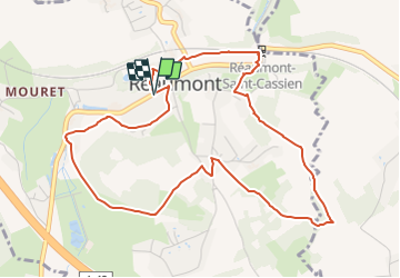
REAUMONT-Le Bessey

raymondfn
User

Length
5.7 km

Max alt
429 m

Uphill gradient
115 m
Km-Effort
7.2 km

Min alt
350 m

Downhill gradient
114 m
Boucle
Yes
Creation date :
2021-05-24 16:13:50.334
Updated on :
2021-10-16 13:11:09.959
1h38
Difficulty : Medium

FREE GPS app for hiking
 SityTrail
IGN / Geographical institutes
SityTrail Plus
The world is yours!
About
Trail Walking of 5.7 km to be discovered at Auvergne-Rhône-Alpes, Isère, Réaumont. This trail is proposed by raymondfn.
Positioning
Country:
France
Region :
Auvergne-Rhône-Alpes
Department/Province :
Isère
Municipality :
Réaumont
Location:
Unknown
Start:(Dec)
Start:(UTM)
697843 ; 5026772 (31T) N.
Comments