


nasbinal saint chely

BELLETGE
User
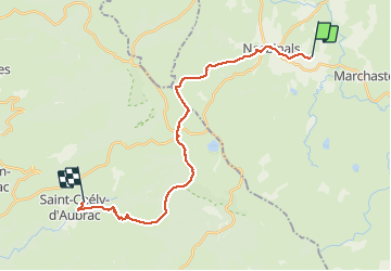

Length
25 km

Max alt
1368 m

Uphill gradient
445 m
Km-Effort
32 km

Min alt
808 m

Downhill gradient
815 m
Boucle
No
Creation date :
2021-05-24 06:42:14.972
Updated on :
2021-05-24 16:39:14.396
7h54
Difficulty : Medium

FREE GPS app for hiking
 SityTrail
IGN / Geographical institutes
SityTrail Plus
The world is yours!
About
Trail Walking of 25 km to be discovered at Occitania, Lozère, Nasbinals. This trail is proposed by BELLETGE.
Positioning
Country:
France
Region :
Occitania
Department/Province :
Lozère
Municipality :
Nasbinals
Location:
Unknown
Start:(Dec)
Start:(UTM)
505726 ; 4944975 (31T) N.
Comments