


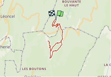
Vercors Sud arche et Roc de Toulau

c.gourme
User

Length
16.9 km

Max alt
1566 m

Uphill gradient
897 m
Km-Effort
29 km

Min alt
771 m

Downhill gradient
901 m
Boucle
Yes
Creation date :
2021-05-23 07:45:04.0
Updated on :
2021-05-25 06:32:10.382
7h14
Difficulty : Medium

FREE GPS app for hiking
 SityTrail
IGN / Geographical institutes
SityTrail Plus
The world is yours!
About
Trail Walking of 16.9 km to be discovered at Auvergne-Rhône-Alpes, Drôme, Bouvante. This trail is proposed by c.gourme.
Description
Au départ suivre les marques jaunes et vertes.
Partir de Grenoble à 8 heures
Positioning
Country:
France
Region :
Auvergne-Rhône-Alpes
Department/Province :
Drôme
Municipality :
Bouvante
Location:
Unknown
Start:(Dec)
Start:(UTM)
677341 ; 4975186 (31T) N.
Comments