


vaux mance hs 12 km

bstebe
User
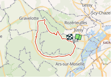

Length
12.3 km

Max alt
354 m

Uphill gradient
302 m
Km-Effort
16.3 km

Min alt
210 m

Downhill gradient
294 m
Boucle
Yes
Creation date :
2021-05-25 11:53:14.909
Updated on :
2021-05-25 15:45:54.739
3h19
Difficulty : Medium

FREE GPS app for hiking
 SityTrail
IGN / Geographical institutes
SityTrail Plus
The world is yours!
About
Trail Walking of 12.3 km to be discovered at Grand Est, Moselle, Vaux. This trail is proposed by bstebe.
Positioning
Country:
France
Region :
Grand Est
Department/Province :
Moselle
Municipality :
Vaux
Location:
Unknown
Start:(Dec)
Start:(UTM)
286906 ; 5441749 (32U) N.
Comments