


SityTrail - sentier lestanouse tournissan

dufland
User
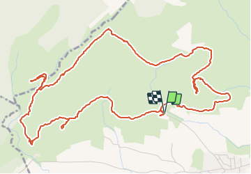

Length
8.3 km

Max alt
299 m

Uphill gradient
260 m
Km-Effort
11.8 km

Min alt
170 m

Downhill gradient
255 m
Boucle
Yes
Creation date :
2021-05-25 15:57:54.598
Updated on :
2022-02-21 09:41:00.54
2h40
Difficulty : Easy

FREE GPS app for hiking
 SityTrail
IGN / Geographical institutes
SityTrail Plus
The world is yours!
About
Trail On foot of 8.3 km to be discovered at Occitania, Aude, Tournissan. This trail is proposed by dufland.
Description
Jolie terres rouges variée facile
Positioning
Country:
France
Region :
Occitania
Department/Province :
Aude
Municipality :
Tournissan
Location:
Unknown
Start:(Dec)
Start:(UTM)
472057 ; 4770642 (31T) N.
Comments