


Bugarach par la fenêtre

Ada11
User GUIDE
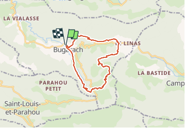

Length
14.1 km

Max alt
1210 m

Uphill gradient
845 m
Km-Effort
25 km

Min alt
458 m

Downhill gradient
845 m
Boucle
Yes
Creation date :
2021-05-26 06:34:42.966
Updated on :
2021-05-26 13:43:42.818
4h31
Difficulty : Medium

FREE GPS app for hiking
 SityTrail
IGN / Geographical institutes
SityTrail Plus
The world is yours!
About
Trail Walking of 14.1 km to be discovered at Occitania, Aude, Bugarach. This trail is proposed by Ada11.
Description
Super
Photos


Positioning
Country:
France
Region :
Occitania
Department/Province :
Aude
Municipality :
Bugarach
Location:
Unknown
Start:(Dec)
Start:(UTM)
446870 ; 4747404 (31T) N.
Comments