


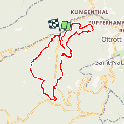
6 châteaux

dragonfr67
User

Length
18.8 km

Max alt
696 m

Uphill gradient
633 m
Km-Effort
27 km

Min alt
346 m

Downhill gradient
630 m
Boucle
Yes
Creation date :
2019-04-26 07:30:12.173
Updated on :
2019-04-26 07:30:12.275
6h58
Difficulty : Easy

FREE GPS app for hiking
 SityTrail
IGN / Geographical institutes
SityTrail Plus
The world is yours!
About
Trail Walking of 18.8 km to be discovered at Grand Est, Bas-Rhin, Ottrott. This trail is proposed by dragonfr67.
Description
Ginkgo 2014
Positioning
Country:
France
Region :
Grand Est
Department/Province :
Bas-Rhin
Municipality :
Ottrott
Location:
Unknown
Start:(Dec)
Start:(UTM)
380689 ; 5368496 (32U) N.
Comments