


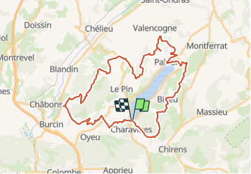
CHARAVINES

cbenoit38
User

Length
42 km

Max alt
740 m

Uphill gradient
1096 m
Km-Effort
57 km

Min alt
486 m

Downhill gradient
1095 m
Boucle
Yes
Creation date :
2021-05-27 12:45:52.0
Updated on :
2021-05-27 15:47:18.98
3h01
Difficulty : Difficult

FREE GPS app for hiking
 SityTrail
IGN / Geographical institutes
SityTrail Plus
The world is yours!
About
Trail Mountain bike of 42 km to be discovered at Auvergne-Rhône-Alpes, Isère, Charavines. This trail is proposed by cbenoit38.
Positioning
Country:
France
Region :
Auvergne-Rhône-Alpes
Department/Province :
Isère
Municipality :
Charavines
Location:
Unknown
Start:(Dec)
Start:(UTM)
696893 ; 5034189 (31T) N.
Comments