


Dentelles de Montmirail 1

pmauvieux
User
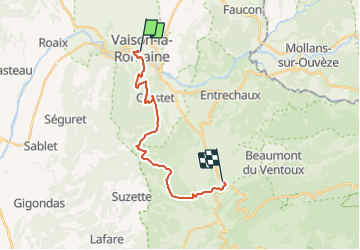

Length
18.4 km

Max alt
605 m

Uphill gradient
627 m
Km-Effort
26 km

Min alt
210 m

Downhill gradient
513 m
Boucle
No
Creation date :
2021-05-27 16:38:56.443
Updated on :
2021-05-27 16:39:50.989
6h00
Difficulty : Very difficult

FREE GPS app for hiking
 SityTrail
IGN / Geographical institutes
SityTrail Plus
The world is yours!
About
Trail Walking of 18.4 km to be discovered at Provence-Alpes-Côte d'Azur, Vaucluse, Vaison-la-Romaine. This trail is proposed by pmauvieux.
Positioning
Country:
France
Region :
Provence-Alpes-Côte d'Azur
Department/Province :
Vaucluse
Municipality :
Vaison-la-Romaine
Location:
Unknown
Start:(Dec)
Start:(UTM)
665670 ; 4900497 (31T) N.
Comments