


Vallée de l'eure (Uzès)

JMJ42
User
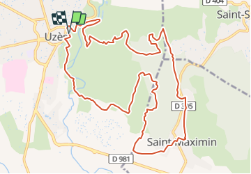

Length
14.5 km

Max alt
184 m

Uphill gradient
329 m
Km-Effort
18.9 km

Min alt
69 m

Downhill gradient
329 m
Boucle
Yes
Creation date :
2021-05-28 17:58:43.964
Updated on :
2021-05-28 17:59:31.626
4h17
Difficulty : Difficult

FREE GPS app for hiking
 SityTrail
IGN / Geographical institutes
SityTrail Plus
The world is yours!
About
Trail Walking of 14.5 km to be discovered at Occitania, Gard, Uzès. This trail is proposed by JMJ42.
Positioning
Country:
France
Region :
Occitania
Department/Province :
Gard
Municipality :
Uzès
Location:
Unknown
Start:(Dec)
Start:(UTM)
614061 ; 4874257 (31T) N.
Comments