


Troussatiere

repiton
User
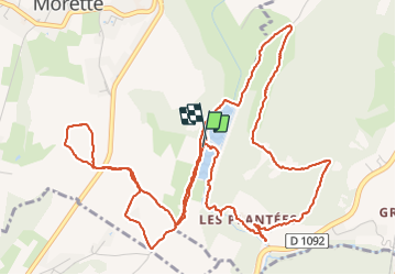

Length
8.5 km

Max alt
403 m

Uphill gradient
250 m
Km-Effort
11.8 km

Min alt
266 m

Downhill gradient
246 m
Boucle
Yes
Creation date :
2021-05-29 06:36:03.295
Updated on :
2021-05-29 10:22:15.272
2h48
Difficulty : Medium

FREE GPS app for hiking
 SityTrail
IGN / Geographical institutes
SityTrail Plus
The world is yours!
About
Trail Walking of 8.5 km to be discovered at Auvergne-Rhône-Alpes, Isère, Tullins. This trail is proposed by repiton.
Positioning
Country:
France
Region :
Auvergne-Rhône-Alpes
Department/Province :
Isère
Municipality :
Tullins
Location:
Unknown
Start:(Dec)
Start:(UTM)
693304 ; 5016723 (31T) N.
Comments