


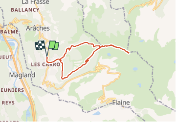
les Carroz, tête de Saix boucle

reneperrin
User


4h08
Difficulty : Medium

FREE GPS app for hiking
 SityTrail
IGN / Geographical institutes
SityTrail Plus
The world is yours!
About
Trail Walking of 14.1 km to be discovered at Auvergne-Rhône-Alpes, Upper Savoy, Arâches-la-Frasse. This trail is proposed by reneperrin.
Description
les Mazots, Timalets par la forêt, corniche de Molliets, Kedeuze, Molliets, tête des Saix.
Retour par la combe de Gron, en ce printemps 2021, la neige qui reste encore assez présente facilite bien la descente..
Photos


Positioning
Comments