


Termes Aumont aubrac

BELLETGE
User
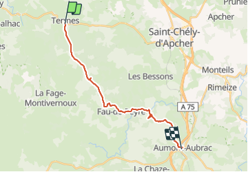

Length
19.5 km

Max alt
1270 m

Uphill gradient
346 m
Km-Effort
24 km

Min alt
994 m

Downhill gradient
430 m
Boucle
No
Creation date :
2021-05-29 06:22:34.281
Updated on :
2021-05-29 13:10:41.853
4h29
Difficulty : Easy

FREE GPS app for hiking
 SityTrail
IGN / Geographical institutes
SityTrail Plus
The world is yours!
About
Trail Walking of 19.5 km to be discovered at Occitania, Lozère, Termes. This trail is proposed by BELLETGE.
Positioning
Country:
France
Region :
Occitania
Department/Province :
Lozère
Municipality :
Termes
Location:
Unknown
Start:(Dec)
Start:(UTM)
513196 ; 4962014 (31T) N.
Comments