


Cascade du Hérisson

geoffrayLayeux
User
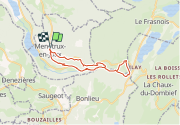

Length
12.3 km

Max alt
775 m

Uphill gradient
413 m
Km-Effort
17.8 km

Min alt
518 m

Downhill gradient
413 m
Boucle
Yes
Creation date :
2021-05-29 14:41:39.086
Updated on :
2021-05-29 14:42:21.977
4h02
Difficulty : Difficult

FREE GPS app for hiking
 SityTrail
IGN / Geographical institutes
SityTrail Plus
The world is yours!
About
Trail Walking of 12.3 km to be discovered at Bourgogne-Franche-Comté, Jura, Menétrux-en-Joux. This trail is proposed by geoffrayLayeux.
Positioning
Country:
France
Region :
Bourgogne-Franche-Comté
Department/Province :
Jura
Municipality :
Menétrux-en-Joux
Location:
Unknown
Start:(Dec)
Start:(UTM)
716604 ; 5167295 (31T) N.
Comments