


DELMAS COUSPEAU

nordan
User
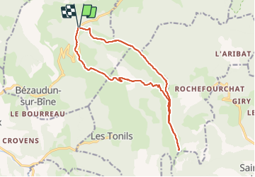

Length
16.2 km

Max alt
1516 m

Uphill gradient
961 m
Km-Effort
29 km

Min alt
833 m

Downhill gradient
964 m
Boucle
Yes
Creation date :
2021-05-29 07:37:47.418
Updated on :
2021-05-29 15:47:44.194
8h08
Difficulty : Very easy

FREE GPS app for hiking
 SityTrail
IGN / Geographical institutes
SityTrail Plus
The world is yours!
About
Trail Walking of 16.2 km to be discovered at Auvergne-Rhône-Alpes, Drôme, Bézaudun-sur-Bîne. This trail is proposed by nordan.
Positioning
Country:
France
Region :
Auvergne-Rhône-Alpes
Department/Province :
Drôme
Municipality :
Bézaudun-sur-Bîne
Location:
Unknown
Start:(Dec)
Start:(UTM)
673236 ; 4943049 (31T) N.
Comments