


Mathesyne Le Piquet de Nantes

c.gourme
User
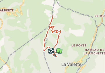

Length
9.8 km

Max alt
2196 m

Uphill gradient
926 m
Km-Effort
22 km

Min alt
1267 m

Downhill gradient
926 m
Boucle
Yes
Creation date :
2021-05-29 06:26:08.0
Updated on :
2021-06-04 16:28:47.772
4h40
Difficulty : Medium

FREE GPS app for hiking
 SityTrail
IGN / Geographical institutes
SityTrail Plus
The world is yours!
About
Trail Walking of 9.8 km to be discovered at Auvergne-Rhône-Alpes, Isère, La Valette. This trail is proposed by c.gourme.
Positioning
Country:
France
Region :
Auvergne-Rhône-Alpes
Department/Province :
Isère
Municipality :
La Valette
Location:
Unknown
Start:(Dec)
Start:(UTM)
724482 ; 4980701 (31T) N.
Comments