


les moulins melisey shunté

PatriceCocuaud
User
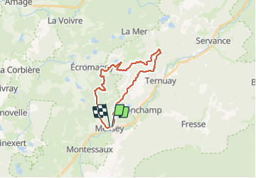

Length
22 km

Max alt
500 m

Uphill gradient
373 m
Km-Effort
27 km

Min alt
327 m

Downhill gradient
369 m
Boucle
Yes
Creation date :
2021-05-30 07:18:40.947
Updated on :
2021-05-30 09:40:08.409
2h21
Difficulty : Medium

FREE GPS app for hiking
 SityTrail
IGN / Geographical institutes
SityTrail Plus
The world is yours!
About
Trail Mountain bike of 22 km to be discovered at Bourgogne-Franche-Comté, Haute-Saône, Mélisey. This trail is proposed by PatriceCocuaud.
Positioning
Country:
France
Region :
Bourgogne-Franche-Comté
Department/Province :
Haute-Saône
Municipality :
Mélisey
Location:
Unknown
Start:(Dec)
Start:(UTM)
318839 ; 5291828 (32T) N.
Comments
Sympa