


le 31 mai 2021

FOUCAULT
User

Length
7.3 km

Max alt
99 m

Uphill gradient
95 m
Km-Effort
8.6 km

Min alt
49 m

Downhill gradient
95 m
Boucle
Yes
Creation date :
2021-05-30 08:25:20.408
Updated on :
2021-05-30 09:53:15.042
1h27
Difficulty : Medium

FREE GPS app for hiking
 SityTrail
IGN / Geographical institutes
SityTrail Plus
The world is yours!
About
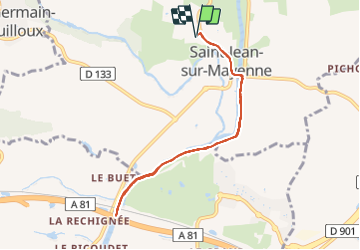
Trail Walking of 7.3 km to be discovered at Pays de la Loire, Mayenne, Saint-Jean-sur-Mayenne. This trail is proposed by FOUCAULT.
Description
marche G
Positioning
Country:
France
Region :
Pays de la Loire
Department/Province :
Mayenne
Municipality :
Saint-Jean-sur-Mayenne
Location:
Unknown
Start:(Dec)
Start:(UTM)
666868 ; 5333696 (30U) N.
Comments