


LISPACH

surceneux
User
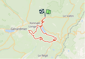

Length
30 km

Max alt
1065 m

Uphill gradient
733 m
Km-Effort
40 km

Min alt
733 m

Downhill gradient
730 m
Boucle
Yes
Creation date :
2021-05-30 07:16:50.379
Updated on :
2021-05-30 11:49:59.33
2h40
Difficulty : Medium

FREE GPS app for hiking
 SityTrail
IGN / Geographical institutes
SityTrail Plus
The world is yours!
About
Trail Mountain bike of 30 km to be discovered at Grand Est, Vosges, Ban-sur-Meurthe-Clefcy. This trail is proposed by surceneux.
Description
SURCENEUX LONGEMER RF DES 17KM LE POLI CHEMIN ST JACQUES RECT VERT ANNEAU BLEU COLLET DE LA MINE LISPACH LAC TOUR COL DES FEIGNES RETOURNEMER LONGEMER TRAVERSE JARDINS SOPHIE SURCENEUX
Positioning
Country:
France
Region :
Grand Est
Department/Province :
Vosges
Municipality :
Ban-sur-Meurthe-Clefcy
Location:
Unknown
Start:(Dec)
Start:(UTM)
347830 ; 5328982 (32U) N.
Comments