Trail Walking Piégut - Tour du ravin de Neyrac Via Piégut - Photo
© OpenStreetMap contributors
Length
Length
5.7 km
Max alt
Max alt
1108 m
Uphill gradient
Uphill gradient
437 m
Km-Effort
Km-Effort  
11.5 km
Min alt
Min alt
677 m
Downhill gradient
Downhill gradient
432 m
Boucle
Boucle
Yes
Creation date :
2021-05-30 08:37:54.922
Updated on :
2021-05-30 14:32:57.753

(0 Reviews)

Walking
Walking
2h10
Difficulty : Medium

Scan this QR Code to open this trail in the SityTrail application

FREE GPS app for hiking

Logo SityTrail SityTrail

IGN / Geographical institutes

Download SityTrail from the App Store Download SityTrail from Google Play

Logo SityTrail SityTrail World

The world is yours!

Download SityTrail from the App Store Download SityTrail from Google Play Download SityTrail on Huawei AppGallery

About

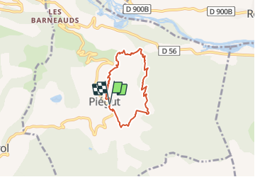
Trail Walking of 5.7 km to be discovered at Provence-Alpes-Côte d'Azur, Alpes-de-Haute-Provence, Piégut. This trail is proposed by PapouBertrand.

Description

Randonnée Marche de 5,7 km, 2h10 et 430 mètres de dénivelé à découvrir à Piégut, Alpes-de-Haute-Provence, Provence-Alpes-Côte d'Azur. Cette randonnée est proposée par PapouBertrand.
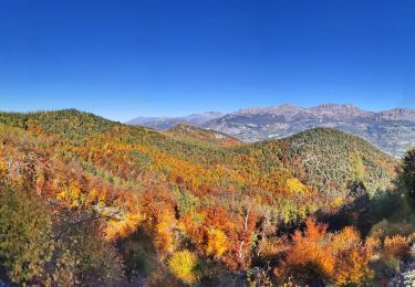
La randonnée peut également démarrer de Neyrac, point bas de la boucle. La rando est assez bien balisée en jaune.
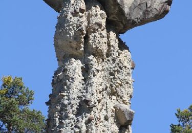
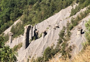
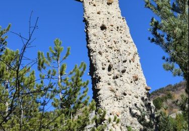
Très belle vue panoramique de la croix du mont Saint Colomban ou il est possible d'écouter un rocher qui parle. Pour entendre le conte, pressez le bouton-poussoir.

Elevation profile

Photos

Positioning

Country:
France
Region :
Provence-Alpes-Côte d'Azur
Department/Province :
Alpes-de-Haute-Provence
Municipality :
Piégut
Location:
Unknown
Start:(UTM)
271574 ; 4926054 (32T) N.

Trails nearby

Trail Walking Théus - R47   Les Demoiselles Coiffees - Photo
Walking
GUIDE+

Walking

Very easy
(2)
Théus, Provence-Alpes-Côte d'Azur, Hautes-Alpes, France
6.7 km | 13.4 km-effort
2h 31min
Yes
Trail Walking Théus - J1 2023 - Theus le Mont Colombis - Photo
Walking
ETMU5496

Walking

Difficult
(1)
Théus, Provence-Alpes-Côte d'Azur, Hautes-Alpes, France
13 km | 25 km-effort
3h 42min
Yes
Trail Electric bike Remollon - Le Puy et la Chapelle Saint-Sixte - Photo
Electric bike
PapouBertrand

Electric bike

Difficult
Remollon, Provence-Alpes-Côte d'Azur, Hautes-Alpes, France
23 km | 31 km-effort
2h 7min
Yes
Trail Electric bike Remollon - VTT-ae - Mont Colombis via Valserres - Croix des prés - Photo
Electric bike
PapouBertrand

Electric bike

Difficult
Remollon, Provence-Alpes-Côte d'Azur, Hautes-Alpes, France
38 km | 58 km-effort
4h 56min
Yes
Trail Mountain bike Remollon - VTT-ae - La Croix des Prés avec V&H - Photo
Mountain bike
PapouBertrand

Mountain bike

Very difficult
Remollon, Provence-Alpes-Côte d'Azur, Hautes-Alpes, France
45 km | 64 km-effort
4h 45min
Yes
Trail Walking Gigors - GIGORS Cretes des Barses par variante n - Photo
Walking
RobinMicheline

Walking

Difficult
Gigors, Provence-Alpes-Côte d'Azur, Alpes-de-Haute-Provence, France
13.8 km | 24 km-effort
4h 46min
Yes
Trail Walking Remollon - Le Balcon de Remollon - Photo
Walking
PapouBertrand

Walking

Difficult
Remollon, Provence-Alpes-Côte d'Azur, Hautes-Alpes, France
8.4 km | 15.5 km-effort
3h 31min
Yes
Trail Walking Théus - Théüs - Salle de bal des demoiselles coiffées - Photo
Walking
ETMU5496

Walking

Medium
Théus, Provence-Alpes-Côte d'Azur, Hautes-Alpes, France
8.6 km | 15.8 km-effort
3h 3min
Yes
Trail Walking Théus - J1 G1 et G2 Théus Salle de bal des demoiselles coiffées - Photo
Walking

Walking

Difficult
Théus, Provence-Alpes-Côte d'Azur, Hautes-Alpes, France
7.5 km | 14.2 km-effort
2h 50min
Yes


Close
My subscriptions