


les vallats du Verdalaï et de Tourenne

amiral13
User GUIDE
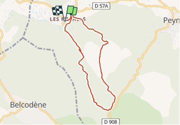

Length
8.1 km

Max alt
420 m

Uphill gradient
198 m
Km-Effort
10.7 km

Min alt
281 m

Downhill gradient
197 m
Boucle
Yes
Creation date :
2021-05-30 12:44:12.52
Updated on :
2021-05-30 15:49:53.593
1h59
Difficulty : Very easy

FREE GPS app for hiking
 SityTrail
IGN / Geographical institutes
SityTrail Plus
The world is yours!
About
Trail Walking of 8.1 km to be discovered at Provence-Alpes-Côte d'Azur, Bouches-du-Rhône, Peynier. This trail is proposed by amiral13.
Photos


Positioning
Country:
France
Region :
Provence-Alpes-Côte d'Azur
Department/Province :
Bouches-du-Rhône
Municipality :
Peynier
Location:
Unknown
Start:(Dec)
Start:(UTM)
710557 ; 4813723 (31T) N.
Comments